


недоступный.
Товар уже продан в нашем интернет-магазине (2009)
Цена: : 35.00 €
Товар уже продан в нашем интернет-магазине (2009)
Цена: : 35.00 €
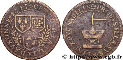
Тип Charles de Trudaine
Дата: 1713
Металл: red copper
Диаметр: 31 mm
Ориентация осей монеты: 6 h.
Век: lisse
Редкость: R2
Ссылки в каталоге: :
Лицевая сторона
Аверс: описание: Armes de Charles de Trudaine.
Обратная сторона
Реверс: легенда: IAM QUANTUS IN ORTU 1713.
Реверс: Описание: Le soleil levant.
Реверс: перевод: Déjà si grand au lever.
Комментарий
Pas de biographie en ligne pour notre personnage mais un intéressant développement à http://pagesperso-orange.fr/jac.deschard/Pomiera1.html
En 1743, la nomination de Daniel Charles de TRUDAINE comme "ministre de l'équipement" va placer un homme capable et énergique aux commandes pour vingt six ans. Dès sa nomination, il voulut presser la réalisation des voies prévues par l'instruction de 1738.
Pour cela il lui fallait réunir deux préalables : la qualification indiscutable des ingénieurs et un lever des plans de routes permettant la rectification des tracés, la prévision des voies à créer et la délimitation des zones des paroisses corvéables.
Pour réaliser ces deux objectifs il créa l'Ecole des Ponts-et-Chaussées en 1747 et un bureau de dessinateurs pour exécuter cet énorme travail cartographique.
Est-il utile de rappeler que la première carte générale moderne de la France est celle de Cassini commencée vers 1750 et terminée seulement en 1815 et qui fut la première carte établie en s'appuyant sur une triangulation géodésique.
No online biography for our character but an interesting development at http://pagesperso-orange.fr/jac.deschard/Pomiera1.html In 1743, the appointment of Daniel Charles de TRUDAINE as \\\"Minister of Equipment\\\" will place a capable and energetic man in command for twenty-six years. From the moment of his appointment, he wanted to hurry the construction of the roads planned by the instruction of 1738. To do this, he needed to meet two prerequisites: the indisputable qualification of the engineers and a survey of road plans allowing the rectification of the routes, the forecasting of the roads to be created and the delimitation of the areas of the corvéable parishes. To achieve these two objectives, he created the School of Bridges and Roads in 1747 and a draftsman's office to carry out this enormous cartographic work. Is it useful to recall that the first modern general map of France is that of Cassini, begun around 1750 and completed only in 1815 and which was the first map established based on geodesic triangulation?
Историческая справка
BURGUNDY - TOWNS AND GENTRY
 Cообщить об ошибке
 Распечатать страницу
 Отправить мой выбор
 Задать вопрос
 Consign / sell
ПОХОЖИЕ ТОВАРЫ
 Информация


Your Recently Viewed Items
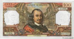
100 Francs CORNEILLE FRANCE 1976 F.65.53 AU-
16.00 €
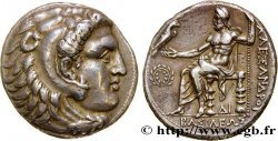
MACEDONIA - MACEDONIAN KINGDOM - ALEXANDER III THE GREAT Tétradrachme AU
550.00 €
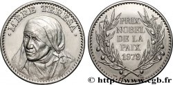
V REPUBLIC Médaille, Mère Thérésa, Prix nobel de la Paix AU
4.00 €
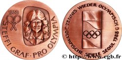
SOUTH KOREA Médaille, Jeux Olympiques, Tennis MS
40.00 €

ITALY 1 Lire Victor Emmanuel II 1863 Milan XF
19.00 €

Concours de 100 francs, essai de Bazor en bronze-aluminium 1929 VG.5216 var. AU
150.00 €